")
")


 The territorial extension is 527.48 km2, with a density population of 40.1 inhab / Km2. Its climatic conditions show notable differences, the southern coastal strip known as the Cuban semi-desert; the northern part influenced by notable rainfall. The climate shows notable differences between the southern region, included in the semi-arid zone of Cuba (southern coastal strip), a very fragile ecosystem due to the lack of rainfall and high temperatures, it is part of the climatic subregion of Eastern Cuba, for which it exhibits semi-arid characteristics thanks to its position with respect to the Nipe-Sagua-Baracoa mountainous massif and in particular the Sierra de Imías, with rainfall values below 800 mm average per year and temperatures above 260C.
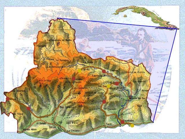
Highlight Imías Vista Alegre with 1193.8 meters above sea level.
The northern region, for its part, receives the most direct influence from the northeast trade winds, causing rainfall to be higher, between 1 600 and 1 800 mm as an annual average, and lower temperatures than in the coastal strip, characteristic of the climate in that height plays an important role.
Its clearly mountainous relief is part of the Nipe-Sagua-Baracoa massif, highlighting the Sierra del Purial and the Sierra de Imías, in the latter the two highest elevations in the province are located: the La Cana peaks, with 1,176.5 meters above mean sea level (masl), and Vista Alegre, with 1 186.5 masl, known as the roof of the province.
It stands out, towards the south of the territory, the coastal strip, of variable amplitude, in which there is a wide manifestation of the coastal karst, where the lapis or dog teeth (ridges and sharp points on the rocks separated by narrow strips) occupies a Much of the coastline, but we also find here important beaches such as Yacabo Abajo, Imías, Tacre and Cajobabo, and smaller ones such as Boquerón, Yime, Managuaco and Guayacanes. The coastal hills (gray mountains), which have a variable height, are typical of the relief in the south of the territory.
The climatic situation, topography and anthropic action have been conditioning progressive desertification and soil degradation, increased aridity and salinity of agricultural space, so measures should be implemented aimed at stopping and reversing as much as possible This process.
It presents a poorly developed hydrographic network due to the prevailing climatic characteristics, together with its geological base. The rivers generally run from north to south, that is, they are born in the Sierra de Imías and El Purial and end in the Caribbean Sea, a characteristic that is denoted more in the Yacabo, Imías, Tacre and Jojó rivers, the latter with the highest flow for receiving the highest rainfall values. All these currents form, when flowing, the well-known tibaracones (sand bar that divides the sea from the river). In some cases they disappear at certain times of the year, such as Tacre. It is estimated that groundwater abounds in the territory, with a potential of close to 3 million cubic meters.
It is important to keep in mind that this network is subject to the action of 13 polluting sources, including coffee pulping, so that not only must the use of water be rationalized, but also foresee, in the short and medium term, other measures that protect all supply sources.
Comments
Interesting cheers for sharing.
My web site :: coupon list for Emma
Mattresses UK here: https://www.vouchersort.co.uk/emma-mattress.co.uk
freezes up
Feel free to visit my webpage; all Joe Browns dscount codes
(torakiti.s22.xrea.com: https://torakiti.s22.xrea.com/keijiban/torakitibbs.cgi)
my web page: 10% off at Joe Browns (odr.info: https://odr.info/forums/topic/womens-jeans-are-a-great-way-to-add-style-to-your-wardrobe/)
RSS feed for comments to this post